The Fremantle Traffic Bridge Is Closing For A Year, Here’s How To Keep Moving

Ready up, Fremantle. One of the city's most prominent—and heavily used—river crossings is about to get a landmark upgrade. The ageing Fremantle Traffic Bridge is set for a 12-month closure starting in February 2026, making way for a sleek, modern replacement.
While this is exciting news for the future, we know a full-year closure of such a key artery is going to shake up our commutes. But fret not! We’ve broken down everything you need to know about the upgrade, the closure and crucially, how to navigate Freo without the gridlock.
The Fremantle Traffic Bridge Closure At A Glance
- Jump To What Is The Fremantle Bridge Upgrade All About?
- Jump To About The Closures: What To Expect & When
- Jump to How To Avoid Delays
What Is The Fremantle Traffic Bridge Upgrade All About?
The current Fremantle Traffic Bridge has been a trooper for its people. Opened in 1939 as a temporary structure, it’s been the fourth bridge on this site and has well and truly served its purpose by connecting North Fremantle and Fremantle over the Swan River. But after decades of service and extensive maintenance, it’s finally time for retirement.
The $430 million replacement will be a striking new extradosed bridge (a combo cable and girder bridge) built on the same alignment. This fifth bridge for the location will be a game-changer, featuring:
- Two traffic lanes in each direction.
- Wider, safer active transport paths for cyclists and pedestrians (up to 4 metres wide).
- Higher clearance for boats and kayaks, improving river navigation.
- A design that minimises impact on the limestone escarpment and, by reducing the number of piers in the river, helps preserve the flow of water important to Whadjuk Aboriginal Songlines and Dreaming Stories, allowing the Spirits to flow freely along the river out towards Wadjemup (Rottnest Island).
While most of the new bridge can be built with the old one still open, a full closure is unavoidable to tie up loose ends. As a final farewell, the government is undertaking a detailed 3D digital capture of the entire existing bridge to preserve its heritage for generations to come.
About The Closures: What To Expect & When
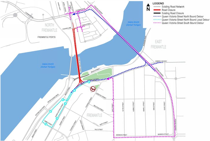
Image Credit: West Cycle | Website
Pencil it in: the big closure is is scheduled to get underway in February 2026 and last for up to 12 months. This means the approximately 24,000 vehicles that use the bridge daily will need to find a new route, with most expected to funnel onto the nearby Stirling Bridge. Traffic modelling forecast warns of severe impacts and delays, so preparation is essential.
The disruption has already started for some and will soon affect everyone. To prepare the network for the main event, several changes are already in place and will remain until late 2026.
For drivers, this includes a no right turn onto the Fremantle Traffic Bridge from Canning Highway and the closure of Beach Street between Queen Victoria Street and East Street. For pedestrians and cyclists, the shared path has been closed since 28 January 2025 and will remain so until the project finishes.
A detour via Stirling Highway will be in place, with other path closures along Queen Victoria Street also in effect so plan your bike rides and walks accordingly. Consult this map to navigate the designated detours and avoid the congestion. Getting familiar with these changes now will pay off when the full closure begins.
How To Avoid Delays
Master the closure by making one simple change: rethink your route. The good news is that the WA State Government is rolling out a full suite of initiatives designed to make ditching your car an easier and cheaper alternative.
Your best bet for a fuss-free commute lies with the significant boost to public transport. The government is genuinely pulling out all the stops, adding four additional train services during peak times and reinforcing key bus routes like the 107, 998 and 999 with extra vehicles to maintain reliable timetables.
To tackle the school-run traffic, dedicated bus services will be introduced for Iona Presentation College, St Hilda’s Anglican School and Presbyterian Ladies’ College. And to top it all off, your wallet gets a break too.
A free-travel zone for SmartRider users will operate on bus services between Douro Road and Fremantle Station, while the new flat fare from January 2026 could save regular commuters up to $27 a week. For those driving to the station, around 100 additional free parking bays will be available at Fremantle Station for train-catching SmartRider users.
However, for the days when you absolutely must drive, a little strategy will go a long way. The plan is to outsmart the traffic.
If your schedule allows, shifting your travel times to avoid the 7-9 am and 4-6 pm peaks can make a world of difference. Consider talking to your colleagues or neighbours about setting up a carpool to reduce the number of vehicles on the road.
And finally, use tech to your advantage. The government will be deploying 18 new cameras and Bluetooth monitors to provide enhanced real-time traffic info, so be sure to check apps like Google Maps or the Main Roads WA site before you head out. You'll also see real-time travel info on Variable Message Signs (VMS) along the highway.
The number one tool at your disposal is the Transperth Journey Planner. Use it to navigate all the public transport changes seamlessly.
This 12-month closure is a short-term pain for a massive long-term gain. By planning ahead and embracing the alternatives, we can all help keep Fremantle moving and welcome a stunning new gateway to our favourite port city.
Main Image Credit: Mainroads WA | Website
See more Urban List in Google Search.