Lace Up And Hit The Best Sunshine Coast Bush Walks (2026 Edition)


If you need a break from the beach and are up-to-date on shows from your last Netflix binge, then there’s really only one solution. Get kitted up in your activewear and shock your system by actually using your Lululemons for their intended purpose.
At Urban List, we're passionate about getting out and about and embracing the pristine Sunshine Coast/Gubbi Gubbi Country we live in. And I personally can't get enough of the views around this part of the Sunshine State. There's just something about experiencing the rugged beauty, the tropical forests and the shore-side adventures all available right here on the Sunshine Coast.
With that in mind, I’ve broken down my pick for the top walks and treks in the region, from a quick stroll to a full day in the wilderness. So, lace up your sneakers, get out there and start exploring the Sunshine Coast's best hikes.
Sunshine Coast Hikes At A Glance
Easy Hikes
Buderim Forest Park
Quorn Cl, Buderim QLD 4556
You've probably heard of Buderim Forest Park, but have you ever actually been there? Starting at either Harry’s Lane or Quorn Close, both paths take you on a spectacular journey through Buderim Mountain’s tranquil bushland, with a soundtrack of birdsong and babbling brooks. It's truly blissful.
I'm a big fan of starting at the Quorn Close entry and heading straight for the rorest loop. It joins up with Serenity Bridge, so if the good times are rolling, sometimes I continue on. Other times I call it a day and scout out my next cafe.
All roads lead to the falls, and if you're brave enough to venture into the chilly waters after working up a sweat, I promise it's worth it. This is one of the easiest and prettiest walks on the Sunshine Coast and truly beautiful year 'round.
THE DETAILS
Where to go: Quorn Cl, Buderim, QLD 4556
Distance: 0.8 kilometres loop | 45 minutes
Grade: Easy
Facilities: Picnic tables, BBQs
What to do: Lunch at Honeysuckle (my favourite's the $45 veg banquet)
More info here
Booloumba Falls
Conondale National Park, Baloumba Creek Rd, Cambroon QLD 4552
This one requires a tad more commitment than the rest, but I assure you, it’s worth the extra effort. Tucked away in the Conondale National Park, the Booloumba Falls track is a hinterland oasis. Think lush open rainforest, crystal-clear rock pools and the biggest boulders you've ever laid eyes on. There are a heap of impressive walks through this National Park.
Head towards Maleny and follow the signs to Kenilworth, then pass through the town of Conondale and take the Booloumba Creek turn-off. Best to take a 4WD for those gravel roads, if possible. It also might be worth kicking it old school with a map, as phone reception can be a bit hit-and-miss. A sense of adventure is a must.
THE DETAILS
Where to go: Conondale National Park, Baloumba Creek Rd, Cambroon QLD 4552
Distance: 3 kilometres | 2 hours
Grade: Easy
Facilities: Nil, BYO supplies
What to do: Double back to Kenilworth Bakery for a 1kg donut challenge (all that hiking will definitely work up your appetite)
More info here
Bribie Island Beach Walk
Bongaree Jetty, First Ave & Toorbul Ln, Bongaree QLD 4507
This hike isn’t technically on the Sunshine Coast, but its a short roadtrip away. And while it isn't as challenging as others, shesure is pretty. Scoot down the Bruce and over the bridge to Bribie Island, parking around Bongaree Jetty. With the beach on one side and bush on the other, this 8km walk is the perfect compromise between a leisurely stroll and an intense hike.
Stop for a swim at Woorim (that’s the divine surf beach) and then follow the tree-lined path back to Bongaree for a milkshake or a trip to the pub. Runners aren’t necessary, but you’ll need shoes of some description. Don’t forget a hat, togs, sunscreen and plenty of water.
THE DETAILS
Where to go: Start at Bongaree Jetty, First Ave & Toorbul Ln, Bongaree QLD 4507
Distance: 8 kilometres | 1.5 hours
Grade: Easy
Facilities: Nil, BYO supplies
What to do: Learn something new at the nearby Bribie Island Seaside Museum
More info here
Emu Mountain
Havana Rd East, Coolum Beach QLD 4573
If hikes were products, this one would have 'best value' stamped all over it. Just between Coolum and Peregian Beach, the Emu Mountain Summit Walk is a short hike with huge rewards.
It goes without saying that you’ll get great views from most mountains around here, but the stunning sights of the region’s mountain peaks, such as our majestic Mount Coolum, are just another perk. Make sure you also stop and smell the roses, literally…Emu Mountain is home to some beautiful flora and I can't help but slow down and inhale their wildflower sweetness on every visit.
While the Hakea Walk scales the western side of the mountain, I prefer the Summit Walk for all the showstoppers. Pack extra water!
THE DETAILS
Where to go: Havana Rd East, Coolum Beach QLD 4573
Distance: 1.3 kilometres return | 45 minutes
Grade: Moderate
Facilities: Nil, BYO supplies
What to do: Picnic at the peak, it's honestly glorious
More info here
Dularcha Tunnel Track
Dularcha National Park, Beach Rd & Cunningham Ave, Landsborough QLD 4550
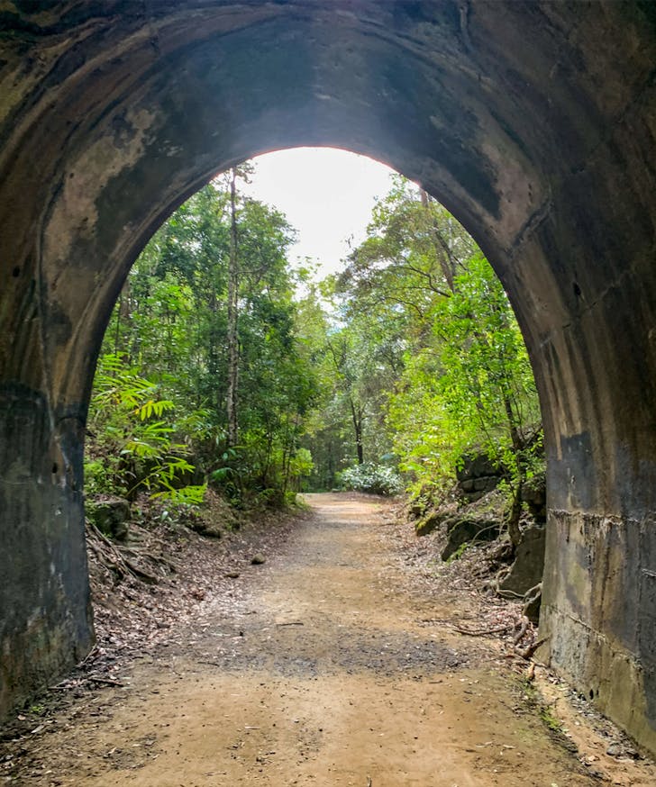
Image Credit: Dularcha Tunnel Track | Aussie Bush Walking
Almost every Sunny Coast walk is sure to provide amazing views but we think we’ve found something a little different. If you're inspired by a little history—and not too put out with the potential of dangling wildlife—the Dularcha Tunnel track might be the perfect spot for you. Built in 1891 and heritage-listed, the Dularcha Tunnel is a 94 metres long railway tunnel.
Set amongst lush cool rainforest surroundings and perfect should you need a place to hide on a warm summer day. Start this track from the southern Landsborough entrance off Beech Road and be sure to bring a torch if you're not overly fond of dark spaces and bats.
THE DETAILS
Where to go: Dularcha National Park, Beach Rd & Cunningham Ave, Landsborough QLD 4550
Distance: 6.6 kilometres | 2 hours one-way
Grade: Easy
Facilities: Nil, BYO supplies
What to do: Watch adorable turtles at nearby Gardners Falls
More info here
You Might Also Like:
- Prettiest Sunshine Coast Walks
- Best Cheap Things To Do On The Sunshine Coast
- Best Spots To Watch Sunsets On Sunshine Coast
Mapleton Falls Lookout
Mapleton National Park, 78 Mapleton Falls Rd, Mapleton QLD 4560
Another of my favourite hinterland walks here on the Sunny Coast is set in lush, scenic bushland. It's a 120-metre tall waterfall with views of Obi Obi valley below. This picturesque Mapleton Falls lookout walk is perfect for rewarding views without the taxing 100-stair price tag.
In fact, you have a choice, pull up and be immediately rewarded with amazing views of the valley below. Or meander the 1.8 km journey around the well maintained dirt and boardwalk track. I guarantee you won’t be disappointed either way.
THE DETAILS
Where to go: Mapleton National Park, 78 Mapleton Falls Rd, Mapleton QLD 4560
Distance: 1.8 kilometres return | 1 hour return
Grade: Easy
Facilities: Picnic tables, BBQ, toilets
What to do: Tuck into a wholesome meal at the Mapleton Pub
More info here
Moderate Hikes
Mount Coolum
Jarnahill Dr (off Tanah St W), Mount Coolum QLD 4573
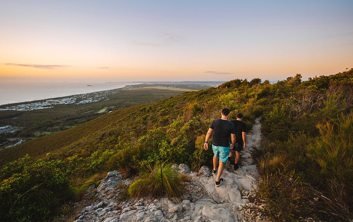
Image Credit: Mount Coolum | TEQ
Mount Coolum is one of the Sunshine Coast's most well-walked hikes, and it's one of my favourites too. So many locals pound this track as their daily walk and I just love that it pulls a crowd of 'morning' chortling people. This is a steep trek up to the summit, which is 197m above sea level, and from the peak you'll be rewarded with stunning 360-degree ocean and hinterland views.
This place is one of Sunshine Coast's ancient volcanic domes, so I think it's pretty cool we have this in our backyard. Keep an eye out for whales during whale watching season, from June to November. Keep an eye out for Peregrine Falcons which are rare beauties that frequent this place. They're actually some of the sparse 25-35 pairs in South-East Queensland. Echidnas and Bandicoots also call this hill home.
THE DETAILS
Where to go: Jarnahill Dr (off Tanah St W), Mount Coolum QLD 4573
Distance: 2.6 kilometres return | 1.5 hours return
Grade: Moderate
Facilities: Nil, BYO supplies
What to do: Round 2 at this nearby boardwalk
More info here
Mount Ninderry
Mount Ninderry, Ninderry QLD 4561
If you're ready to get that blood pumping Mount Ninderry will not disappoint. I always opt to take the scenic drive through Yandina as I make my way upwards to the already reasonably high starting point carpark.
From there, be sure to tie those running shoes tight as you prepare to make the non-stop upward climb to the summit above—think Mount Coolum but with denser bushland. Once you’ve conquered the stairs prepare to be rewarded with not one, but two viewing platforms of the canefields below and Maroochy River surrounds. Perfect for avid sunrise hikers.
THE DETAILS
Where to go: Mount Ninderry, Ninderry QLD 4561
Distance: 3.3 kilometres | 1.5 hour
Grade: Moderate
Facilities: Picnic tables
What to do: Checkout The Birdcatcher Gallery Saturdays 8am-2pm
More info here
Hard Hikes
Kondalilla Falls
Kondalilla National Park, Montville QLD 4560
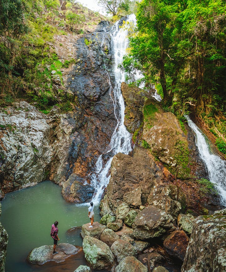
Image Credit: Kondalilla Falls | TEQ
Kondalilla, the Aboriginal term for “rushing water”, is exactly that. In fact, it’s 90 meters of rushing water plummeting into a gorgeous valley. This stunning walking track leads from Kondalilla Falls down the escarpment into a lush rainforests valley, which is ripe with prime photo opportunities.
If you’re after a real adventure, ditch the easy 2.4km Picnic Creek Circuit, even the moderate 3.2km Rock Pools walk, and get lost on the 4.6km Kondalilla Falls Circuit. It's my favourite kind of hike that delivers big views and a whole lot of chatting time.
This subtropical rainforest trail winds around chilled gorges and secluded rock pools with plenty of scenic lookouts along the way. Hint: use this opportunity to take in the view, and some deep breaths too, because once you reach the main event, it’s another 4.6km back. After all, what goes down must come back up.
THE DETAILS
Where to go: Kondalilla National Park, Montville QLD 4560
Distance: 4.6 kilometres one-way | 2 hours one-way
Grade: Hard
Facilities: Nil, BYO supplies
What to do: Splurge on a stay at Woody Grove Retreat
More info here
Yul-yan Man Track
8 Beerburrum Rd, Beerburrum QLD 4517
If it's rock-scrambling you're after, the Yul-yan Man Track is the Sunshine Coast hike of your dreams. It translates to 'walk slowly' in Kabi Kabi language and I invite you to pay attention to this sentiment. Rated hard with a capital h, it's a good idea to take a walking buddy on this one. You two or the crew may need to amp each other up to navigate some of the trail's tricky patches.
It starts with an uphill scramble and a couple of rockface crossings, though the track across the ridge is much less intense to traverse. Immediately after the second lookout is a steep decline, but you might surprise yourself with how you make your way down - even if the strategy is crab-crawl on your bum.
THE DETAILS
Where to go: Beerburrum State School Carpark, 8 Beerburrum Rd, Beerburrum QLD 4517
Distance: 9 kilometres return | 4 hours return
Grade: Hard
Facilities: Picnic tables, toilets
What to do: Refuel with a juicy burger at nearby Cafe Phillies
More info here
Trachyte Circuit
Mount Tibrogargan Carpark, Glasshouse Mountains, QLD 4518
I'm not kidding when I say that the open woodlands, sweeping lookouts and beauty that emerges here during misty rainy weather is life-changing. The views of Mount Tibrogargan are truly breathtaking. The native plants put on a show with their stunning florals year 'round, though particularly in Spring.
A lot of Sunny Coasters rate this one moderate, but I honestly found this quite challenging (especially the scramble to the very top, if you get a chance), so I'm rating it as one of the harder hikes on the Sunshine Coast. This particular track is often quieter and is home to a heap of birdlife which makes for a great soundtrack and an epic sight.
THE DETAILS
Where to go: Mount Tibrogargan Carpark, Glasshouse Mountains, QLD 4518
Distance: 6.4 kilometres loop | 4 hours return
Grade: Hard
Facilities: Picnic tables, toilets
What to do: Get caffeinated at nearby Lookout Cafe
More info here
Looking for more?
- Things To Do In The Glasshouse Mountains
- The Sunshine Coast's Best Beaches
- The Best Things To Do In Maleny
Main image credit: Lumea Photography
Urban List Best Of: has our highest stamp of approval—curated lists of the very best recommendations for you to eat, do, see, buy or book, carefully chosen by our Editors